Registros (15) Pessoas (25) Ana Tenório "Alvarez" (1) Antônio de Madureira Morais (1) Antonio Ruiz de Montoya (1595-1652) (1) Balthazar Fernandes (1580-1667) (1) Cláudio Furquim de Camargo (1) Cristovão Diniz (2) Custódio Bicudo (1) Diogo Domingues de Faria (1618-1690) (1) Francisco Pedroso Xavier (1635-1680) (1) Gaspar Vaz Guedes (1) Izabel da Costa (1) Izabel da Costa Diniz (1) Jaime Comas (Jayme Commere) (1) João Dias de Arzão (1) João IV, o Restaurador (1) José Maria da Silva Paranhos (1) Juan Sebastián Elcano (n.1476) (1) Luiz Fernandes Folgado (1) Manuel Lourenço de Andrade (1) Nicolas del Techo (1611-1680) (1) Paulo de Proença e Abreu (f.1676) (1) Pedro de Sousa Pereira (2) Pedro Fernandes (1) Salvador Correia de Sá e Benevides (1594-1688) (1) Simão de Vasconcelos (1597-1671) (1) Cidades (20) Araçariguama/SP (1) Barueri/SP (1) Carapicuiba/SP (1) Cotia/Vargem Grande/SP (1) Embu das Artes/SP (1) Itajaí/SC (1) Itapecirica da Serra/SP (1) Itu/SP (1) Jundiaí/SP (1) Mogi das Cruzes/SP (1) Paranaguá/PR (2) Rio de Janeiro/RJ (1) Santana de Parnaíba/SP (3) Santo Amaro/SP (2) Santos/SP (1) São Francisco do Sul/SC (2) São Paulo/SP (3) São Roque/SP (1) São Vicente/SP (1) Sorocaba/SP (6) Temas (21) Bandeirantes (1) Caminho do Mar (1) Capela de NS Monserrate (1) Engenho(s) de Ferro (1) Ermidas, capelas e igrejas (2) Gados (1) Geografia e Mapas (2) Guaramimis (1) Ituguasu (1) Metalurgia e siderurgia (1) Nossa Senhora da Assunção (1) Nossa Senhora da Graça do Rio de São Francisco (1) Nossa Senhora de Montserrate (1) Nossa Senhora do Rosário (1) Ouro (1) Primeira Matriz (1) Rio Anhemby / Tietê (1) Rio Pinheiros (1) Santa Ana das Cruzes (1) Vila Nossa Senhora do Rosário (1) Vuturuna (1)
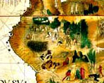
Paraquaria Vulgo Paraguay Cum adjacentibus
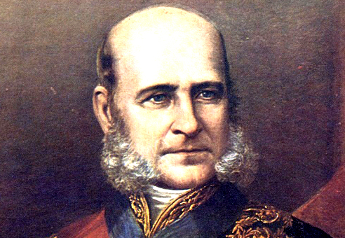
Personagens (3) Antonio Ruiz de Montoya (1595-1652) José Maria da Silva Paranhos Nicolas del Techo (1611-1680)
Temas (1) Geografia e Mapas
An Important Geographical Advance 1889 1645 1649 1662 É muito valioso e o melhor dos mapas jesuítas para estudar a história das missões no século XVII e compreender os textos de Duran, Montoya, Techo e outros jesuítas, e muito interessante pela abundância de informação geográfica que apresenta para o primeiro época, indicando todas as grandes características de grande parte do interior da América do Sul. 1585 1649 Publication History and Census 1645 1658 1672 1688 1700 1690 1596 1673 1633 1638 1616 1648 1662 1672 1712 1608 1645 1658 1688 1712 1688 1712 1737 1706 1665 2024 2024 1690 1658 1889 1645 1649 1662 1585 1649 1645 1658 1672 1688 1700 1690 1596 1673 1633 1638 1616 1648 1662 1672 1712 1608 1645 1658 1688 1712 1688 1712 1737 1706 1665 2024 2024 1690 1690 1658 1658 1889 1645 1649 1662 1585 1649 1645 1658 1672 1688 1700 1690 1596 1673 1633 1638 1616 1648 1662 1672 1712 1608 1645 1658 1688 1712 1688 1712 1737 1706 1665 8650 2024 2024 1690 1690 1658 1658 1889 1645 1649 1662 1585 1649 1645 1658 1672 1688 1700 1690 1596 1673 1633 1638 1616 1648 1662 1672 1712 1608 1645 1658 1688 1712 1688 1712 1737 1706 1665 8650 2024
O homem brasileiro, desde o faxineiro até o Presidente da República, nenhum deles sai de casa dizendo hoje ‘vou errar, hoje vou errar’. Não. Não! Todos saem de casa com a intenção de acertar. Fazem 10 coisas, erram três e os jornais e a televisão, sem dó, encontram os três defeitos. Não encontra uma só qualidade. Qual é o ser humano que vai progredir se ele não recebe estímulo da televisão?
75 “ Nada é mais difícil e, portanto, tão precioso, do que ser capaz de decidir.
Brasilbook.com.br
Selecionar ano 150 (3) 200 (1) 325 (1) 326 (2) 330 (1) 380 (1) 384 (1) 391 (1) 415 (1) 480 (1) 484 (1) 500 (1) 503 (1) 529 (1) 542 (1) 547 (1) 656 (1) 710 (1) 751 (1) 829 (1) 900 (1) 930 (1) 955 (1) 1000 (1) 1048 (1) 1113 (2) 1118 (1) 1119 (1) 1128 (1) 1139 (1) 1147 (1) 1174 (1) 1195 (1) 1198 (1) 1202 (1) 1214 (1) 1219 (1) 1220 (1) 1229 (2) 1234 (1) 1240 (1) 1250 (1) 1257 (1) 1263 (1) 1270 (2) 1291 (1) 1300 (1) 1302 (2) 1307 (1) 1312 (2) 1317 (1) 1319 (1) 1322 (1) 1328 (1) 1333 (1) 1334 (1) 1342 (1) 1343 (1) 1345 (1) 1350 (1) 1352 (1) 1357 (1) 1360 (1) 1367 (1) 1369 (1) 1375 (1) 1378 (1) 1380 (1) 1404 (2) 1405 (1) 1406 (1) 1408 (2) 1409 (1) 1411 (1) 1414 (1) 1415 (1) 1417 (1) 1420 (1) 1421 (2) 1423 (1) 1424 (1) 1428 (2) 1431 (2) 1432 (2) 1433 (1) 1434 (1) 1435 (1) 1436 (1) 1438 (3) 1439 (2) 1443 (1) 1444 (2) 1448 (1) 1449 (1) 1450 (2) 1451 (3) 1452 (3) 1453 (1) 1454 (4) 1455 (4) 1457 (2) 1458 (1) 1460 (1) 1462 (3) 1464 (1) 1467 (1) 1468 (2) 1469 (1) 1470 (2) 1472 (4) 1474 (1) 1475 (1) 1476 (2) 1477 (1) 1479 (2) 1480 (2) 1481 (2) 1483 (1) 1484 (1) 1485 (3) 1487 (1) 1488 (3) 1489 (1) 1490 (1) 1491 (1) 1492 (3) 1493 (7) 1494 (4) 1495 (4) 1496 (4) 1497 (1) 1498 (5) 1499 (5) 1500 (8) 1501 (44) 1502 (22) 1503 (21) 1504 (13) 1505 (11) 1506 (7) 1507 (5) 1508 (3) 1509 (7) 1510 (1) 1511 (4) 1512 (9) 1513 (7) 1514 (5) 1515 (6) 1516 (10) 1517 (8) 1518 (6) 1519 (1) 1520 (10) 1521 (12) 1522 (7) 1523 (6) 1524 (1) 1525 (12) 1526 (7) 1527 (15) 1528 (6) 1529 (8) 1530 (2) 1531 (15) 1532 (28) 1533 (27) 1534 (13) 1535 (25) 1536 (22) 1537 (16) 1538 (13) 1539 (9) 1540 (9) 1541 (20) 1542 (13) 1543 (13) 1544 (10) 1545 (16) 1546 (10) 1547 (4) 1548 (7) 1549 (15) 1550 (36) 1551 (35) 1552 (31) 1553 (38) 1554 (56) 1555 (41) 1556 (32) 1557 (42) 1558 (40) 1559 (21) 1560 (19) 1561 (56) 1562 (30) 1563 (44) 1564 (34) 1565 (14) 1566 (30) 1567 (21) 1568 (28) 1569 (25) 1570 (13) 1571 (27) 1572 (13) 1573 (25) 1574 (15) 1575 (7) 1576 (28) 1577 (19) 1578 (18) 1579 (20) 1580 (38) 1581 (48) 1582 (57) 1583 (23) 1584 (56) 1585 (25) 1586 (37) 1587 (16) 1588 (24) 1589 (32) 1590 (41) 1591 (53) 1592 (47) 1593 (61) 1594 (31) 1595 (42) 1596 (36) 1597 (27) 1598 (28) 1599 (53) 1600 (44) 1601 (64) 1602 (34) 1603 (43) 1604 (41) 1605 (23) 1606 (34) 1607 (35) 1608 (46) 1609 (45) 1610 (88) 1611 (57) 1612 (52) 1613 (37) 1614 (26) 1615 (29) 1616 (52) 1617 (37) 1618 (24) 1619 (39) 1620 (32) 1621 (44) 1622 (21) 1623 (26) 1624 (20) 1625 (65) 1626 (53) 1627 (26) 1628 (48) 1629 (59) 1630 (42) 1631 (53) 1632 (53) 1633 (45) 1634 (69) 1635 (48) 1636 (58) 1637 (51) 1638 (57) 1639 (68) 1640 (78) 1641 (96) 1642 (51) 1643 (35) 1644 (35) 1645 (24) 1646 (96) 1647 (48) 1648 (52) 1649 (59) 1650 (38) 1651 (31) 1652 (16) 1653 (25) 1654 (39) 1655 (55) 1656 (34) 1657 (19) 1658 (22) 1659 (14) 1660 (18) 1661 (51) 1662 (47) 1663 (21) 1664 (19) 1665 (19) 1666 (22) 1667 (10) 1668 (24) 1669 (19) 1670 (14) 1671 (22) 1672 (19) 1673 (17) 1674 (17) 1675 (23) 1676 (15) 1677 (19) 1678 (18) 1679 (16) 1680 (40) 1681 (51) 1682 (72) 1683 (28) 1684 (16) 1685 (18) 1686 (16) 1687 (9) 1688 (18) 1689 (19) 1690 (16) 1691 (21) 1692 (14) 1693 (15) 1694 (17) 1695 (16) 1696 (18) 1697 (7) 1698 (24) 1699 (29) 1700 (17) 1701 (57) 1702 (36) 1703 (15) 1704 (12) 1705 (19) 1706 (12) 1707 (8) 1708 (7) 1709 (4) 1710 (22) 1711 (27) 1712 (48) 1713 (9) 1714 (19) 1715 (14) 1716 (11) 1717 (2) 1718 (18) 1719 (10) 1720 (20) 1721 (34) 1722 (28) 1723 (29) 1724 (27) 1725 (25) 1726 (21) 1727 (22) 1728 (20) 1729 (28) 1730 (14) 1731 (22) 1732 (7) 1733 (15) 1734 (29) 1735 (21) 1736 (23) 1737 (22) 1738 (19) 1739 (14) 1740 (16) 1741 (15) 1742 (4) 1743 (8) 1744 (8) 1745 (10) 1746 (16) 1747 (15) 1748 (21) 1749 (11) 1750 (18) 1751 (22) 1752 (18) 1753 (14) 1754 (13) 1755 (22) 1756 (22) 1757 (29) 1758 (16) 1759 (9) 1760 (15) 1761 (20) 1762 (13) 1763 (19) 1764 (29) 1765 (19) 1766 (37) 1767 (54) 1768 (60) 1769 (33) 1770 (52) 1771 (38) 1772 (27) 1773 (32) 1774 (29) 1775 (24) 1776 (19) 1777 (35) 1778 (32) 1779 (18) 1780 (11) 1781 (25) 1782 (12) 1783 (25) 1784 (33) 1785 (18) 1786 (13) 1787 (14) 1788 (15) 1789 (38) 1790 (24) 1791 (23) 1792 (20) 1793 (25) 1794 (23) 1795 (13) 1796 (19) 1797 (32) 1798 (23) 1799 (39) 1800 (19) 1801 (49) 1802 (62) 1803 (22) 1804 (43) 1805 (24) 1806 (31) 1807 (22) 1808 (26) 1809 (62) 1810 (28) 1811 (39) 1812 (53) 1813 (37) 1814 (22) 1815 (20) 1816 (25) 1817 (49) 1818 (80) 1819 (72) 1820 (64) 1821 (48) 1822 (77) 1823 (218) 1824 (130) 1825 (87) 1826 (110) 1827 (104) 1828 (119) 1829 (89) 1830 (41) 1831 (54) 1832 (74) 1833 (51) 1834 (42) 1835 (50) 1836 (92) 1837 (87) 1838 (52) 1839 (77) 1840 (92) 1841 (137) 1842 (55) 1843 (132) 1844 (63) 1845 (51) 1846 (54) 1847 (63) 1848 (39) 1849 (57) 1850 (46) 1851 (56) 1852 (71) 1853 (50) 1854 (55) 1855 (45) 1856 (57) 1857 (52) 1858 (53) 1859 (46) 1860 (39) 1861 (60) 1862 (48) 1863 (47) 1864 (56) 1865 (86) 1866 (117) 1867 (105) 1868 (99) 1869 (130) 1870 (117) 1871 (96) 1872 (67) 1873 (81) 1874 (67) 1875 (78) 1876 (77) 1877 (51) 1878 (56) 1879 (54) 1880 (68) 1881 (102) 1882 (47) 1883 (58) 1884 (43) 1885 (43) 1886 (45) 1887 (63) 1888 (46) 1889 (76) 1890 (170) 1891 (85) 1892 (67) 1893 (38) 1894 (38) 1895 (36) 1896 (58) 1897 (42) 1898 (38) 1899 (36) 1900 (52) 1901 (59) 1902 (39) 1903 (34) 1904 (42) 1905 (31) 1906 (32) 1907 (42) 1908 (31) 1909 (42) 1910 (33) 1911 (65) 1912 (49) 1913 (59) 1914 (57) 1915 (49) 1916 (41) 1917 (29) 1918 (65) 1919 (72) 1920 (37) 1921 (68) 1922 (89) 1923 (68) 1924 (72) 1925 (52) 1926 (43) 1927 (52) 1928 (80) 1929 (67) 1930 (69) 1931 (97) 1932 (63) 1933 (75) 1934 (73) 1935 (72) 1936 (50) 1937 (62) 1938 (73) 1939 (87) 1940 (64) 1941 (84) 1942 (69) 1943 (82) 1944 (58) 1945 (81) 1946 (66) 1947 (62) 1948 (77) 1949 (63) 1950 (66) 1951 (71) 1952 (60) 1953 (63) 1954 (59) 1955 (82) 1956 (76) 1957 (51) 1958 (91) 1959 (66) 1960 (67) 1961 (82) 1962 (78) 1963 (70) 1964 (69) 1965 (82) 1966 (54) 1967 (53) 1968 (73) 1969 (101) 1970 (109) 1971 (77) 1972 (72) 1973 (80) 1974 (86) 1975 (74) 1976 (79) 1977 (77) 1978 (84) 1979 (89) 1980 (87) 1981 (69) 1982 (62) 1983 (131) 1984 (61) 1985 (52) 1986 (67) 1987 (63) 1988 (50) 1989 (48) 1990 (63) 1991 (72) 1992 (52) 1993 (68) 1994 (63) 1995 (59) 1996 (64) 1997 (68) 1998 (63) 1999 (70) 2000 (70) 2001 (41) 2002 (51) 2003 (56) 2004 (56) 2005 (61) 2006 (239) 2007 (74) 2008 (63) 2009 (62) 2010 (66) 2011 (116) 2012 (111) 2013 (119) 2014 (110) 2015 (118) 2016 (104) 2017 (118) 2018 (108) 2019 (156) 2020 (166) 2021 (215) 2022 (89) 2023 (256) 28375 registros (15,54% da meta) 2243 personagens 1070 temas 640 cidades
Agradecemos as duvidas, criticas e sugestoes
Contato: (15) 99706.2000 Sorocaba/SP